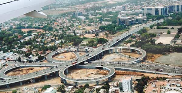
Kathipara Bridge, officially known as the Kathipara Grade Separator, is one of the largest and most complex flyover systems in Chennai. Located at the busy intersection of Anna Salai (Mount Road), Inner Ring Road, and GST Road (NH-45), it serves as a critical multi-level interchange connecting South Chennai with the airport, Tambaram, and other major parts of the city.
Inaugurated in 2008, this massive flyover complex was built to ease severe traffic congestion at the Kathipara junction. It features multiple levels, loops, and ramps, making it a major landmark in Chennai’s road infrastructure.
Kathipara Bridge Location
Kathipara Bridge is situated in Guindy, at the junction of Anna Salai, Inner Ring Road, and GST Road.
- Address: Kathipara Grade Separator, Guindy, Anna Salai, Chennai, Tamil Nadu
- PIN Code: 600032
- Type: Multi-level Grade Separator / Flyover System
- Significance: One of Chennai’s busiest and most important road interchanges
How to Reach Kathipara Bridge
| From | Distance | Approx. Time | Best Options |
| Chennai International Airport | 5–7 km | 15–25 minutes | Cab, Taxi, MTC Bus |
| Guindy Metro Station | 1–2 km | 5–10 minutes | Auto / Walking |
| Tambaram | 18–22 km | 35–60 minutes | Bus / Cab via GST Road |
| Chennai Central Railway Station | 12–14 km | 30–50 minutes | Cab / Metro |
| Adyar | 6–8 km | 15–30 minutes | Cab / Auto |
| Egmore Railway Station | 10–12 km | 25–45 minutes | Cab |
Road & Bridge Connectivity
- Connects Anna Salai (Mount Road), Inner Ring Road, and GST Road (NH-45).
- Provides direct access towards the Airport, Tambaram, Guindy, Saidapet, and Adyar.
- Features multiple elevated levels and loop ramps for smooth traffic movement.
- Heavily used by cars, buses, and airport traffic.
- Served by several MTC bus routes with stops near the junction.
Nearby Areas and Landmarks
| Landmark / Area | Distance | Description |
| Guindy Industrial Estate | Adjacent | Major industrial and commercial zone. |
| Chennai International Airport | 5–7 km | Domestic and international airport. |
| Guindy National Park | 3–4 km | One of the few national parks within a city limit. |
| Raj Bhavan | 4–5 km | Official residence of the Governor of Tamil Nadu. |
| IIT Madras | 5–6 km | Premier engineering institution. |
| Alwarpet / Teynampet | 6–8 km | Upscale residential and commercial areas. |
| Little Mount | 2–3 km | Historic Christian pilgrimage site. |
Significance
Kathipara Bridge is a vital infrastructure project that has significantly reduced travel time for commuters heading to the airport and southern suburbs. Being at the crossroads of several major roads, it handles very high traffic volume daily. Though it often experiences congestion during peak hours, it remains one of the most important connectors in Chennai’s road network.
Frequently Asked Questions (FAQs)
Q1. Where is Kathipara Bridge located?
A: It is at the junction of Anna Salai, Inner Ring Road, and GST Road in Guindy, Chennai.
Q2. When was Kathipara Bridge inaugurated?
A: It was opened to traffic in 2008.
Q3. Why is Kathipara Bridge important?
A: It is a major grade separator that connects multiple key roads and provides smooth access to Chennai Airport and southern suburbs.
Q4. Is traffic heavy at Kathipara Bridge?
A: Yes, it is one of the busiest junctions in Chennai, especially during peak hours.
Q5. What is the nearest Metro station to Kathipara Bridge?
A: Guindy Metro Station (Blue Line) is the closest, just 1–2 km away.