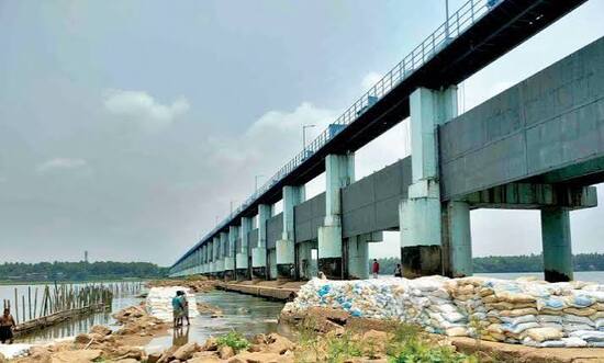
Chamravattom Bridge, officially known as the Chamravattom Regulator-cum-Bridge, is one of the longest bridges in Kerala. It spans the Bharathapuzha River (Nila River) and serves both as a major road bridge and a water regulator for irrigation purposes.
Inaugurated on 17 May 2012 by then Chief Minister Oommen Chandy, this bridge has significantly improved connectivity between Malappuram and neighbouring districts while helping manage irrigation in the region.
Chamravattom Bridge Location
The bridge is located near Chamravattom village in Triprangode Panchayat, between Ponnani and Tirur in Malappuram district.
- Address: Chamravattom Regulator-cum-Bridge, Bharathapuzha River, Triprangode, Malappuram District, Kerala
- PIN Code: 676102
- Length: 978 metres
- Width: 10.5 metres
- Type: Regulator-cum-Road Bridge
- Significance: One of Kerala’s longest bridges with dual purpose of transportation and irrigation
How to Reach Chamravattom Bridge
| From | Distance | Approx. Time | Best Options |
| Tirur Town | 12–15 km | 25–40 minutes | Cab, Auto, KSRTC Bus |
| Ponnani | 10–12 km | 20–35 minutes | Cab / Bus |
| Malappuram Town | 35–40 km | 1 – 1.5 hours | Cab / Bus |
| Kozhikode (Calicut) | 55–60 km | 1.5 – 2 hours | Bus / Cab |
| Kochi (Ernakulam) | 110–120 km | 3 – 3.5 hours | Bus / Cab (via the bridge route) |
| Palakkad | 80–85 km | 2 – 2.5 hours | Bus / Cab |
Road & Bridge Connectivity
- Connects Tirur and Ponnani sides across the Bharathapuzha River.
- Part of the important Malappuram coastal road network.
- Reduces travel distance between Kozhikode and Ernakulam by nearly 40 km.
- The bridge includes a regulator with shutters to control water flow for irrigation in the command area.
- Well-connected by KSRTC and private buses.
Nearby Areas and Landmarks
| Landmark / Area | Distance | Description |
| Bharathapuzha River (Nila) | Beneath the bridge | Kerala’s second-longest river, culturally significant. |
| Tirur | 12–15 km | Historic town known as the birthplace of Thunjath Ezhuthachan. |
| Ponnani | 10–12 km | Important coastal town with rich cultural heritage. |
| Chamravattom Village | Adjacent | Peaceful village surrounding the bridge. |
| Keralam Museum & Park | 35–40 km | Popular cultural museum in Malappuram. |
| Tirunavaya Temple | 20–25 km | Ancient temple on the banks of Bharathapuzha. |
Significance
Chamravattom Bridge is not only a major transportation link but also serves a critical irrigation role through its regulator system. It has boosted economic activity, improved connectivity to the coastal belt of Malappuram district, and reduced travel time for thousands of daily commuters. The long stretch of the bridge over the wide Bharathapuzha offers scenic views, especially during the monsoon season.
Frequently Asked Questions (FAQs)
Q1. Where is Chamravattom Bridge located?
A. It is across the Bharathapuzha River near Tirur and Ponnani in Malappuram district, Kerala.
Q2. When was Chamravattom Bridge inaugurated?
A. It was inaugurated on 17 May 2012 by Oommen Chandy, the then Chief Minister of Kerala.
Q3. How long is the Chamravattom Bridge?
A. The bridge is 978 metres long and 10.5 metres wide.
Q4. What is special about this bridge?
A. It is a Regulator-cum-Bridge — serving both transportation and irrigation needs.
Q5. Is it a good place to visit?
A. Yes, especially for those travelling between Tirur and Ponnani. The bridge offers scenic views of the Bharathapuzha River.