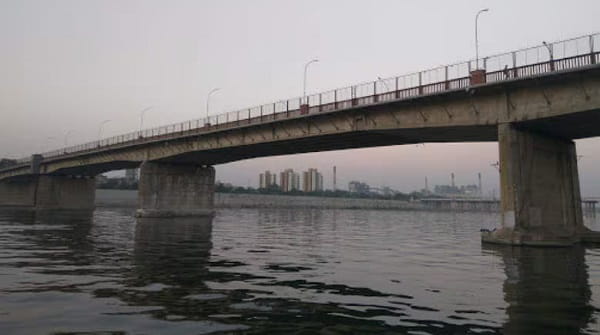
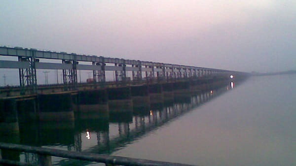
Farakka Bridge — the iconic rail-cum-road bridge built as part of the Farakka Barrage complex across the Ganga River in Murshidabad district, West Bengal — is one of the most strategically vital infrastructure landmarks in eastern India, a structure that has served for decades as the only direct road and rail communication link between West Bengal south of the Ganga and the entire North-Eastern Region of India. The Farakka Barrage itself — commissioned on 21 April 1975 and built at a cost of ₹1 billion — is a 2,304-metre long barrage across the Ganga in Murshidabad district, approximately 300 kilometres north of Kolkata and 18 kilometres from the Bangladesh border. Constructed by Hindustan Construction Company and designed to divert 40,000 cusecs of Ganga water through a 38.38-kilometre feeder canal into the Bhagirathi-Hooghly river system to preserve the navigability of Kolkata Port and prevent siltation, the Farakka Barrage is one of the largest and most complex water diversion projects in Asia.
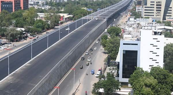
The rail-cum-road bridge built across the Ganga at Farakka as part of this complex established the critical direct overland connection between the mainland of India and the North-Eastern states — a strategic national priority that has only grown more important over the decades. As of 2026, an extraordinary new chapter in Farakka’s infrastructure story is unfolding: the New Farakka Bridge — a dedicated four-lane road bridge stretching 5.468 kilometres across the Ganga, built at a cost of ₹622.04 crore, with 96% physical progress completed as of February 2026 — is nearing inauguration and will dramatically ease the chronic traffic congestion on the existing barrage that has made the Farakka crossing one of West Bengal’s most notorious daily bottlenecks, where commuters currently lose 1 to 2 hours in peak-hour queues. The new bridge will reduce travel time between Malda and Murshidabad significantly, improve connectivity to Darjeeling, Kalimpong, Kurseong, and Sikkim, and open markets for the famed mangoes and litchis of Malda and Murshidabad to wider national reach.
Farakka Bridge Location
Farakka Bridge (rail-cum-road bridge at Farakka Barrage) and the New Farakka Bridge are both located at Farakka in Murshidabad district, West Bengal — on the Ganga River approximately 300 kilometres north of Kolkata and 18 kilometres from the Bangladesh border.
- Address: Farakka Bridge / Farakka Barrage, Farakka, Murshidabad District, West Bengal — 742212
- Pin Code: 742212
- Administrative Zone: Farakka Community Development Block — Murshidabad District / Murshidabad Lok Sabha Constituency
| Reference Point | Distance |
| Farakka Barrage Project Office | At the barrage |
| Farakka Railway Station | 1 to 2 kilometres |
| Farakka Barrage Township | Adjacent |
| Jangipur | 20 kilometres |
| Murshidabad Town | 50 kilometres |
| Malda Town | 35 kilometres |
| Azimganj / Jiaganj | 40 kilometres |
| Baharampur | 55 kilometres |
| Kolkata | 300 kilometres |
| Dhaka (Bangladesh) | 180 kilometres (across border) |
| Bhagalpur (Jharkhand side) | 55 kilometres |
| Netaji Subhash Chandra Bose International Airport, Kolkata | 300 kilometres |
Directions to Farakka Bridge
Farakka Bridge is accessible from Malda, Murshidabad, Kolkata, and across Bihar–Jharkhand via National Highway 12 (NH-12 / former NH-34) which is the primary Kolkata–Malda–Siliguri National Highway corridor.
From Kolkata
Take NH-12 northward → approximately 300 kilometres — 6 to 7 hours by road. Long-distance NBSTC / private buses from Esplanade Bus Terminus to Malda / Siliguri pass through Farakka.
From Malda Town
Take NH-12 southward toward Farakka → approximately 35 kilometres — 50 to 70 minutes.
From Murshidabad Town
Take state highway northward toward Jangipur–Farakka → approximately 50 to 70 kilometres — 1.5 to 2 hours.
By Train
Take a train on the Sealdah–Malda–New Jalpaiguri (NJP) corridor → alight at Farakka Railway Station → approximately 1 to 2 kilometres to the barrage and bridge.
From Bhagalpur (Bihar)
Cross via road toward Jharkhand–West Bengal border → connect to Farakka via NH-12 → approximately 55 kilometres — 1 to 1.5 hours.
Road and Highway Connectivity Farakka Bridge
| Route | Direction | Connectivity |
| National Highway 12 (former NH-34) | North–South primary | Kolkata (south) — Malda, Siliguri, North Bengal (north) |
| NH-12 — Toward Jharkhand | West | Rajmahal (Jharkhand) — Bihar–Jharkhand border approach |
| Farakka Feeder Canal Road | Internal | Along the 38.38-km feeder canal corridor |
| Farakka–Jangipur Road | South | Jangipur, Murshidabad, Baharampur |
| Malda–Farakka Road | North | Malda town, English Bazar, North Bengal corridor |
| New Farakka Bridge (upcoming 4-lane) | Parallel to barrage | 5.468 km new dedicated four-lane road bridge — nearing inauguration (2026) |
Railway Connectivity Farakka Bridge
| Station | Distance | Line | Notes |
| Farakka Railway Station | 1 to 2 km | Eastern Railway | Nearest station on Sealdah–Malda–NJP corridor |
| Malda Town Railway Station | 35 km | Eastern Railway | Major junction — trains toward Kolkata, NJP, Patna |
| Kolkata (Howrah / Sealdah) | 300 km | Eastern Railway | Full corridor — multiple daily express trains |
The rail-cum-road bridge at Farakka is a dedicated infrastructure that forms part of the Farakka Barrage project — carrying the railway line that connects West Bengal with the North-Eastern states, and road traffic across the Ganga simultaneously. This bridge has been the lifeline of the entire northeast India rail corridor for nearly five decades.
Bus and Transit Connectivity Farakka Bridge
| Service | Details |
| NBSTC (North Bengal State Transport Corporation) | Regular bus services on NH-12 passing through Farakka — Kolkata to Siliguri, Malda, and NE states |
| Private Long-Distance Buses | Multiple private operators connecting Kolkata–Malda–Siliguri via Farakka |
| CSTC / Private AC Sleeper | Night sleeper buses from Kolkata to North Bengal via Farakka |
| Local Auto-Rickshaw | Available at Farakka town for last-mile access to the barrage and bridge viewpoints |
| Shared Cycle Rickshaw | Available within Farakka township |
Nearby Areas and Landmarks Farakka Bridge
| Landmark / Area | Distance | Description |
| Farakka Barrage Project Office | Adjacent | The engineering complex that manages the 2,304-metre barrage and feeder canal |
| Farakka Barrage Township | Adjacent | Planned township of the Farakka Barrage Project staff — schools, hospital, recreation |
| Farakka Super Thermal Power Station (NTPC) | 5 km | 2,100 MW NTPC power plant powered by Farakka feeder canal water |
| Jangipur | 20 km | Major commercial and political town in Murshidabad |
| Murshidabad (Hazarduari Palace) | 50 km | Nawabi capital — Hazarduari Palace, Imambara, historic tombs |
| Malda (Gour–Pandua) | 35 km | Archaeological ruins of medieval Bengal — Gour Fort, Adina Mosque |
| Kulik Bird Sanctuary | 55 km | Asia’s second-largest rookery — heron, cormorant, egret colonies |
| Rajmahal Hills (Jharkhand) | 55 km | Heritage and geological site across the Ganga |
Frequently Asked Questions (FAQs)
Q1. Where is Farakka Bridge located in West Bengal?
A: Farakka Bridge is at Farakka, Murshidabad District, West Bengal — PIN 742212 — on the Ganga River approximately 300 kilometres north of Kolkata and 18 kilometres from the Bangladesh border. The Farakka Barrage was commissioned on 21 April 1975.
Q2. What is the New Farakka Bridge being built?
A: A new dedicated four-lane road bridge of 5.468 kilometres is being constructed parallel to the ageing Farakka Barrage at a cost of ₹622.04 crore — with 96% completion as of February 2026 — designed to ease chronic congestion and serve as one of the Ganga’s longest road bridges.
Q3. How do I reach Farakka Bridge from Kolkata?
A: Take NH-12 northward — approximately 300 kilometres and 6 to 7 hours by road or overnight bus. By train: take the Sealdah–Malda Town corridor and alight at Farakka Railway Station.
Q4. Why is Farakka Bridge strategically important for India?
A: The rail-cum-road bridge at Farakka is the primary surface connectivity link between mainland India and the entire North-Eastern Region — the lifeline rail corridor connecting Assam, Meghalaya, Tripura, Manipur, Mizoram, Nagaland, and Arunachal Pradesh to the rest of the country for nearly five decades.
Q5. What is the purpose of the Farakka Barrage?
A: The Farakka Barrage diverts 40,000 cusecs of Ganga water into the 38.38-kilometre feeder canal leading to the Bhagirathi-Hooghly river system — flushing out silt from Kolkata Port to maintain its navigability, supplying freshwater to Kolkata and surrounding areas, and providing cooling water to the NTPC Farakka Super Thermal Power Station.