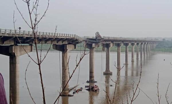
Gambhira Bridge is a road bridge over the Gambhira River (a small river/channel) located in Murshidabad district, West Bengal. It lies on the Kuli–Moregram Road and serves as an important local connectivity link in the central part of Murshidabad district.
This bridge plays a key role in connecting rural areas and small towns in the region, supporting daily commuters, agricultural transport, and local trade. While not as famous as major river bridges on the Ganga or Bhagirathi, it is a vital infrastructure point for villagers and travellers in the Kuli–Moregram corridor.
Gambhira Bridge Location
The bridge is situated on the Kuli–Moregram Road near Gambhira village/area in Murshidabad district.
- Address: Gambhira Bridge, Kuli–Moregram Road, Murshidabad District, West Bengal
- PIN Code: 742235 (Kuli area) / Nearby villages
- Type: Reinforced Concrete (R.C.) Hollow Box Girder Bridge
- District: Murshidabad
- Significance: Local road connectivity bridge in the fertile plains of Murshidabad
How to Reach Gambhira Bridge
| From | Distance | Approx. Time | Best Options |
| Berhampore (Baharpur) | 25–30 km | 45–70 minutes | Bus, Taxi, Auto |
| Kuli | 4–6 km | 10–15 minutes | Auto / E-rickshaw |
| Moregram | 12–15 km | 25–35 minutes | Bus / Taxi |
| Jangipur | 35–40 km | 1 – 1.5 hours | Bus via Moregram |
| Murshidabad Town | 40–45 km | 1 – 1.5 hours | Cab / Bus |
| Kolkata | 220–240 km | 5 – 6 hours | Train to Berhampore + Road |
Road & Bridge Connectivity
- Located on the Kuli–Moregram Road, an important district road.
- Connects villages on both sides of the Gambhira River/channel.
- Used mainly by light to medium vehicles, buses, and agricultural transport.
- Part of the local road network linking to NH-12 (old NH-34) and other state highways.
Nearby Areas and Landmarks
| Landmark / Area | Distance | Description |
| Kuli | 4–6 km | Local town with market and basic amenities. |
| Moregram | 12–15 km | Important road junction with better connectivity. |
| Berhampore | 25–30 km | District headquarters and major commercial centre. |
| Gambhira Village | Adjacent | Rural settlement near the bridge. |
| Bhagirathi River (Main) | 15–25 km | The mighty Bhagirathi River is relatively close. |
| Hazarduari Palace & Imambara | 35–40 km | Famous historical sites of Murshidabad. |
Significance
Gambhira Bridge is a typical example of important district-level infrastructure in West Bengal’s rural heartland. It supports the local economy by enabling the movement of people and agricultural produce in the fertile Murshidabad region, known for its silk, rice, and jute cultivation. While modest in size compared to major bridges, it holds daily importance for thousands of residents in the surrounding villages.
Frequently Asked Questions (FAQs)
Q1. Where is Gambhira Bridge located?
A: It is on the Kuli–Moregram Road in Murshidabad district, West Bengal, spanning the Gambhira River/channel.
Q2. Which is the nearest major town to Gambhira Bridge?
A: Kuli is the closest, while Berhampore (the district headquarters) is the nearest major town (25–30 km).
Q3. What type of vehicles can cross the Gambhira Bridge?
A: It is used by light vehicles, buses, autos, and agricultural vehicles. Heavy truck movement may be limited.
Q4. How to reach Gambhira Bridge from Berhampore?
A: You can take a local bus or hire a cab/taxi towards Kuli–Moregram Road (approx. 45–70 minutes).
Q5. Is Gambhira Bridge a tourist spot?
A: No, it is primarily a functional local bridge. Tourists usually visit historical sites like Hazarduari, Katra Masjid, and Nashipur Palace in Murshidabad.