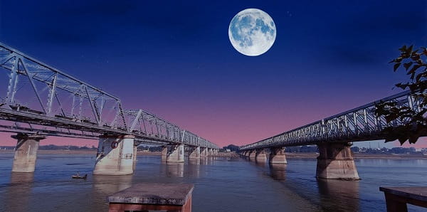
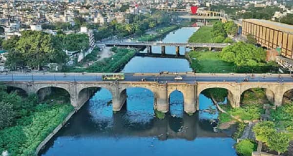
Subhash Bridge — the venerable concrete beam bridge spanning the Sabarmati River in the Shahibag–Ranip zone of northern Ahmedabad — is one of the city’s oldest, most historically resonant, and most institutionally significant road bridges across the sacred Sabarmati, standing 453.7 metres long and 12.8 metres wide at coordinates 23°04′N 72°35′E. Built in 1973 and named after the fearless freedom fighter Netaji Subhash Chandra Bose, the bridge has served as one of Ahmedabad’s primary river crossings for over five decades — connecting the eastern bank institutions of the Regional Transport Office (RTO), the Collector Office, the Shahibag belt, and the Sabarmati River Ashram corridor with the western bank residential zones of Ranip, Chandkheda approach, Sabarmati Railway Station vicinity, and the northern Ahmedabad growth belt.
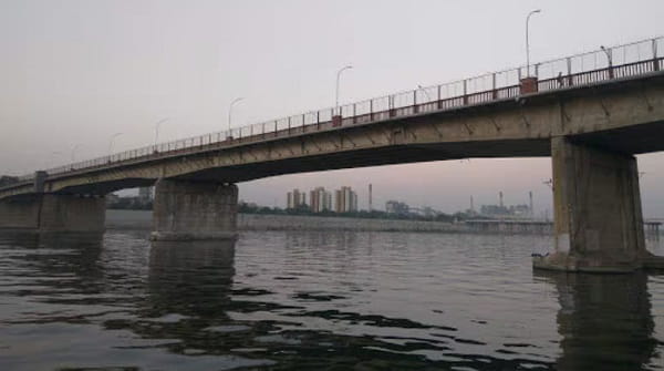
The bridge occupies a historically charged position on the Ahmedabad urban map — flanked by the Sabarmati Ashram (Mahatma Gandhi’s most celebrated residence, approximately 1.5 kilometres south) and the Moti Shahi Mahal (Shahibag Palace, the 17th-century Mughal heritage garden), making it a bridge that physically connects two of India’s most important historical heritage zones. The Subhash Bridge zone is also immediately adjacent to the RTO Circle — one of Ahmedabad’s most active civic circles — and the BRTS corridor, confirming its position as a daily multi-modal transit reference. The first AMTS bus near Subhash Bridge (Route 88) departs at 6:45 AM and the last (Route 13/1) runs until 10:34 PM. The nearest Gujarat Metro stations are Sabarmati Metro Station on the Red Line (6 minutes’ walk from RTO Circle BRTS) and Ranip Metro Station (14 minutes’ walk from the bridge). Note: Subhash Bridge was closed on 4 December 2025 for structural repairs and strengthening work — travellers are advised to check the current operational status with the Ahmedabad Municipal Corporation before visiting or planning routes through it.
Subhash Bridge Location
Subhash Bridge spans the Sabarmati River in the Shahibag–Ranip zone of northern Ahmedabad — between the RTO Circle, Collector Office, and Shahibag institutions on the eastern bank and the Ranip residential belt on the western bank.
- Address: Subhash Bridge, Sabarmati River, Shahibag / Ranip, Ahmedabad, Gujarat — 380013 / 380005
- Pin Code: 380013 (east bank) / 380005 (west bank)
- STD Code: 079
- Administrative Zone: Shahibag Ward / Sabarmati Zone — Ahmedabad Municipal Corporation / Sabarmati Assembly Constituency
| Reference Point | Distance |
| R.T.O. Circle BRTS Station | 115 to 133 metres — 2 to 3-minute walk |
| Subhash Bridge Circle | 162 metres — 3-minute walk |
| Collector Office | 385 metres — 6-minute walk |
| Keshavnagar Tanki | 456 metres — 7-minute walk |
| Vadaj Metro Station (Line 2) | 960 metres — 13-minute walk |
| Sabarmati Metro Station (Red Line) | 6 minutes’ walk from RTO area |
| Ranip Metro Station (Line 2) | 14-minute walk (west bank) |
| Sabarmati Ashram (Gandhi Ashram) | 1.5 kilometres south |
| Moti Shahi Mahal (Shahibag Palace) | 1.5 kilometres east |
| Ahmedabad Railway Station (Kalupur) | 5 kilometres |
| SVPI Airport | 10 kilometres |
| Gandhinagar Capital | 22 kilometres |
Directions to Subhash Bridge
Subhash Bridge is accessible from central Ahmedabad via Ashram Road northward and from the western zones via the Ranip–Sabarmati approach corridor.
From Ahmedabad Railway Station (Kalupur)
Take Ashram Road northward → continue past Gandhi Ashram → approximately 5 kilometres — 10 to 15 minutes by AMTS bus or auto-rickshaw. Routes 22 and 88 serve the Subhash Bridge corridor.
From CG Road (Navrangpura)
Take Ashram Road northward → approximately 5 kilometres — 12 to 18 minutes by auto-rickshaw.
From Gandhigram Metro Station (Line 2)
Take Line 2 northward to Vadaj Metro Station → walk 13 minutes to Subhash Bridge. Alternatively, take Line 2 to Sabarmati Station (6-minute walk to the bridge zone).
From Gandhinagar Capital
Take NH-147 southward toward Ahmedabad → continue via Sabarmati zone → approximately 22 kilometres — 30 to 40 minutes.
From SVPI International Airport
Take Airport Road southward → connect to Ashram Road → approximately 10 kilometres — 20 to 30 minutes by cab.
Road Connectivity Subhash Bridge
| Road | Direction | Connectivity |
| Ashram Road | South toward city | Gandhigram, Ellis Bridge, CG Road, Lal Darwaja |
| Shahibag Road | East | Shahibag, Moti Shahi Mahal, Raksha Shakti Circle |
| Ranip Road | West | Ranip residential belt, Chandkheda direction |
| RTO Circle Road | Adjacent | Regional Transport Office, Collector Office |
| NH-147 (via Sabarmati Zone) | North toward Gandhinagar | Gandhinagar Capital, GIFT City, SP Ring Road north |
| Sabarmati Riverfront Walkway | South | Sabarmati Ashram, Atal Bridge (south) |
AMTS and BRTS Bus Connectivity Subhash Bridge
| Route / Service | Service Details |
| Route 88 | First bus at Subhash Bridge Circle at 6:45 AM |
| Route 13/1 | Last bus at Subhash Bridge Circle at 10:34 PM |
| Routes 12D / 15D / 15U | Via Subhash Bridge Circle — Ashram Road corridor |
| Routes 200 / 202 | Via Subhash Bridge Circle — cross-city services |
| Routes 3D / 22 | Via Subhash Bridge Circle — city services |
| Routes 130/4 / 18S / 89/1 | Via Subhash Bridge zone — Ranip and Sabarmati approaches |
| R.T.O. Circle BRTS | BRTS stop 133 metres from the bridge — connecting the Janmarg BRTS corridor on Ashram Road |
| Route 204 / 205 / 4D | Via RTO Circle / Subhash Bridge area |
First AMTS service: Route 88 at 6:45 AM. Last AMTS service: Route 13/1 at 10:34 PM.
Metro Connectivity Subhash Bridge
| Station | Line | Distance | Notes |
| Vadaj Metro Station | Line 2 (Blue Line — North–South) | 960 metres — 13-minute walk | Nearest Metro — Line 2 access |
| Sabarmati Metro Station | Red Line (Line 1) | 6-minute walk (from RTO area) | Red Line — Motera to APMC corridor |
| Ranip Metro Station | Line 2 (Blue Line) | 14-minute walk (west bank) | Western approach Metro access |
First Line 2 Metro near Subhash Bridge: 9:04 AM. Last Red Line Metro: 9:52 PM.
Railway Connectivity Subhash Bridge
| Station | Distance | Line | Notes |
| Sabarmati Junction | 1 kilometre | Western Railway | Nearest station — secondary |
| Ahmedabad Railway Station (Kalupur) | 5 km | All lines | Main Ahmedabad terminus |
Nearby Areas and Landmarks Subhash Bridge
| Landmark / Area | Distance | Description |
| RTO Circle (Regional Transport Office) | Adjacent | Ahmedabad’s main vehicle registration and licensing office |
| Sabarmati Ashram (Gandhi Ashram) | 1.5 km | Mahatma Gandhi’s most celebrated residence (1917–1930) — national heritage monument |
| Moti Shahi Mahal (Shahibag Palace) | 1.5 km | 17th-century Mughal heritage garden and palace complex |
| Atal Pedestrian Bridge | 4 km south | Ahmedabad’s iconic kite-shaped riverfront footbridge |
| Raksha Shakti University Circle | 1 km | South Asia’s first security sciences university junction |
| Gandhi Ashram Shopping Area | 1.5 km | Khadi stores, handloom textiles, Gandhi heritage merchandise |
| Civil Hospital (Asarwa) | 2 km | Gujarat’s largest government hospital complex |
| Bhadra Fort (Old City) | 5 km | 15th-century fort — Ahmedabad’s historic citadel |
Frequently Asked Questions (FAQs)
Q1. Where is Subhash Bridge located in Ahmedabad?
A: Subhash Bridge spans the Sabarmati River between Shahibag (east) and Ranip (west), northern Ahmedabad — PIN 380013 — adjacent to RTO Circle BRTS and approximately 1.5 kilometres from Gandhi Ashram. It was built in 1973 and is named after Netaji Subhash Chandra Bose.
Q2. Is Subhash Bridge currently open for traffic?
A: Subhash Bridge was closed on 4 December 2025 for structural repairs and strengthening work. Travellers should check the current operational status with Ahmedabad Municipal Corporation before planning routes through the bridge.
Q3. Which Metro stations are nearest to Subhash Bridge?
A: Vadaj Metro Station (Line 2 / Blue Line) is 960 metres away — 13-minute walk. Sabarmati Metro Station (Red Line) is a 6-minute walk from the RTO Circle area. Ranip Metro Station (Line 2) is 14 minutes from the west bank approach.
Q4. Which AMTS routes serve Subhash Bridge?
A: Routes 88, 13/1, 12D, 15D, 15U, 200, 202, 3D, 22, 130/4, 18S, 204, and 205 serve the Subhash Bridge and RTO Circle zone. First bus at 6:45 AM (Route 88), last at 10:34 PM (Route 13/1).
Q5. How far is Gandhi Ashram from Subhash Bridge?
A: Approximately 1.5 kilometres south along the Sabarmati Riverfront — a 5-minute auto-rickshaw ride or 18-minute walk along the riverfront promenade.