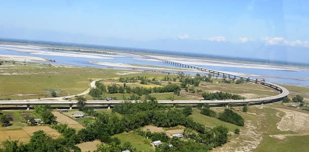
Dhola–Sadiya Bridge, officially known as Bhupen Hazarika Setu, is India’s longest bridge over water. This impressive 9.15 km long beam bridge spans the Lohit River (a major tributary of the Brahmaputra) and connects Dhola in Assam with Sadiya in Arunachal Pradesh.
Inaugurated on 26 May 2017 by Prime Minister Narendra Modi, the bridge is a game-changer for connectivity in India’s Northeast. It provides the first permanent all-weather road link between northern Assam and eastern Arunachal Pradesh and holds strategic importance for defence and regional development.
Dhola–Sadiya Bridge Location
The bridge is located in Tinsukia district of Assam, near the Assam–Arunachal Pradesh border.
- Address: Bhupen Hazarika Setu / Dhola–Sadiya Bridge, Dhola (Assam) to Sadiya (Arunachal Pradesh)
- PIN Code: 786001 (approx. Tinsukia / Dhola)
- Length: 9.15 km
- Width: 12.9 metres
- Type: Multi-span beam bridge
- Significance: India’s longest bridge over water
How to Reach Dhola–Sadiya Bridge
| From | Distance | Approx. Time | Best Options |
| Tinsukia Town | 35–40 km | 45–70 minutes | Cab, Taxi, Sumo |
| Dibrugarh | 80–90 km | 2 – 2.5 hours | Cab / Bus |
| Dibrugarh Airport | 95–100 km | 2.5 – 3 hours | Cab / Taxi |
| Guwahati | 480–500 km | 10 – 12 hours | Train to Tinsukia + Cab |
| Sadiya (Arunachal Side) | At the end | – | Direct crossing |
| Roing (Arunachal Pradesh) | 40–45 km | 1 – 1.5 hours | Via Sadiya side |
Best Route: Most visitors drive from Tinsukia or Dibrugarh. The bridge itself is motorable, and you can cross it by vehicle.
Road & Bridge Connectivity
- Connects NH-15 (Assam side) with roads leading into Arunachal Pradesh.
- Designed to withstand heavy loads, including 60-tonne military tanks.
- Significantly reduces travel time to eastern Arunachal Pradesh (previously required long detours).
- Part of the strategic infrastructure in the India-China border region.
Nearby Areas and Landmarks
| Landmark / Area | Distance | Description |
| Sadiya Town | At the bridge end | Historic town, once the capital of the Chutia Kingdom. |
| Bhupen Hazarika Park | Nearby | Memorial park dedicated to the legendary singer-musician. |
| Tinsukia Town | 35–40 km | Commercial hub of Upper Assam with markets and amenities. |
| Digboi Oil Refinery & Museum | 60–65 km | Asia’s first oil refinery and war memorial. |
| Dibru-Saikhowa National Park | 70–80 km | Famous for wild horses, biodiversity, and riverine landscape. |
| Margherita | 50–55 km | Coal mining town with scenic surroundings. |
Significance
The Dhola–Sadiya Bridge (Bhupen Hazarika Setu) is a symbol of progress in Northeast India. Named after the legendary musician and filmmaker Dr. Bhupen Hazarika, it has transformed the lives of people in this remote region by improving access to education, healthcare, trade, and tourism. It is also of immense strategic value for faster movement of defence forces.
Frequently Asked Questions (FAQs)
Q1. What is the length of Dhola–Sadiya Bridge?
A: The bridge is 9.15 km long, making it India’s longest bridge over water.
Q2. When was the Dhola–Sadiya Bridge inaugurated?
A: It was inaugurated on 26 May 2017 by Prime Minister Narendra Modi.
Q3. Which river does the bridge cross?
A: It spans the Lohit River, a major tributary of the Brahmaputra.
Q4. Can tourists cross the bridge?
A: Yes, the bridge is open for all vehicles and is a popular spot for travellers to stop and take photos.
Q5. What is the best time to visit?
A: October to March offers pleasant weather and clear views. Monsoon (June–September) brings lush greenery but heavy rainfall.